Sacramento History Online

Historic Sacramento Photograph and Document Archive


View Large Image
Title
Sutter's Grant or New Helvetia
Date
[ca.. 1839]
Description
1 map ; 11 14/ x 6 7/8 image on 12 1/4 x 8 1/2 in. sheet
Subject(s)
Summary
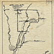
Map of New Helvetia, 48,l818 acres. Shows Sutter Buttes in the north to land south of Sutter's Fort in the south including Yuba City, Marysville, Sutter's Hock Farm, Sacramento, and the Yuba, Feather, Bear, Sacramento, and American Rivers. Original drawing for book: "Hills of Gold" by Herman Daniel Jerrett, 1963.
Owning
Institution
California State Library, California History Room
Copyright
© California State Library, California History Room
Call
Number
c912.C15 1839
Filing
Location
MAP-S: CALIFORNIA. NORTHERN. ca. 1839
You may refine your search results or perform a new search by returning to the search page.