Sacramento History Online

Historic Sacramento Photograph and Document Archive


View Large Image
Title
Map of Rutte, Muldrow & Smith's gardens
Publisher
Sacramento ; G.H. Goodard
Date
[1857]
Description
1 map : col, mounted on linen ; 25 1/2 x 38 1/2 in.
Subject(s)
Summary
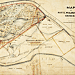
Map shows land bounded on the west by 31st Street (Alhambra Blvd.), on the north and east by the American River, and on the south by open land south of the Sutter Fort slough. Shows land tracts and houses (each identified by owner's name), woods, fetrry routes, levees, and other development. Most land shown was purchased from J. A. Sutter.
Owning
Institution
California State Library, California History Room
Copyright
© California State Library, California History Room
Call
Number
c912.S12a 1857
Filing
Location
MAP-VAULT: SACRAMENTO COUNTY. 1857
Other
Formats
Negative, no. 27,507 (8 x 10 in. color transparency, 4 X 5 in. b/w)
You may refine your search results or perform a new search by returning to the search page.