Sacramento History Online

Historic Sacramento Photograph and Document Archive


View Large Image
Title
[Lands of the Tideland Reclamation Company]
Publisher
San Francisco : Britton & Rey
Date
1869
Description
1 map : 18 x 25 in.
Subject(s)
Summary
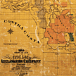
Map showing lands of the Tideland Reclamation Company, compiled and drawn by J.T. Gibbes. Shows islands, rivers, creeks, railroad lines, ranchos (Sacramento, San Joaquin, Yolo, Solano, and Contra Costa Counties; Sacramento at top of map, Rancho el Pescadero at bottom.
Owning
Institution
California State Library, California History Room
Copyright
© California State Library, California History Room
Call
Number
c912.C15g 1869
Filing
Location
MAP: CALIFORNIA. CENTRAL. 1869
Other
Formats
Negative, no. 27,474 (4 x 5 in. b/w, 8 x 10 in. color transparency)
You may refine your search results or perform a new search by returning to the search page.