 |
 |
||||||||
|
|
Lessons Menu - Lesson 1 - Lesson 2 - Lesson 3 - Lesson 4 - Lesson 5 - Lesson 6 - Lesson 7 - Lesson 8 |
| Lesson Plan 3 - Transportation TRANSPORTATION IN SACRAMENTO COUNTY |
download
lesson03.pdf |
|
|
OVERVIEW STUDENT OBJECTIVES CALIFORNIA HISTORY STANDARDS BACKGROUND ARTICLE 3 STUDENT ACTIVITY SHEET 3 AND KEY |
ADDITIONAL ITEMS AVAILABLE IN THIS LESSON PLAN: |
|
DOCUMENTS TO DISCUSS
(view online or print screen) |
||||
 view large image |
1. Californie. Vue de la Ville de Sacramento [ca. 1850] View of Sacramento from the Sacramento River looking east. |
 view large image |
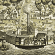
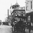
2. Sacramento wharf area with the steamboat, Yosemite. [ca. 1874] At the dock of the California Steam Navigation Company. |
|
 view large image |
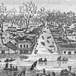
3. Inundation of the State Capitol, City of Sacramento [1850] Depiction of the 1850 flood, one of many over the years. Eventually the downtown streets and many buildings were raised as much as 10 feet. |
|||
|
Changes over Time
(downtown streets, changes over a day, over years) |
||||
 download PDF file |
4a. Street and river scenes - Sacramento
[1878] The top image is a street scene downtown, possibly 12th and I Streets, while the middle picture shows Front and K Streets in what is now Old Sacramento. The bottom view is the Sacramento River waterfront and the first railroad bridge. |
 view large image |
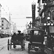
4b. K Street near Seventh. [ca. 1910] View looking east down K Street; post office at left; horse-drawn wagons and carriages, automobiles, bicycles, and people fill the streets and sidewalks. |
|
 view large image |
4c. Automobiles, horse-drawn vehicles, trolley, downtown Sacramento [ca. 1910] This image is taken at the same place as 4b, probably on the same day by the same photographer. |
 view large image |
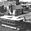
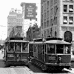
4d. Street cars on J Street [ca. 1924] This image shows cars and streetcars in downtown Sacramento about 14 years after #4b and #4c. Most wagons have been replaced by cars. |
|
Changes over Time
(same downtown street ca. 1909 and ca. 1924)
|
||||
 view large image |
5a. Horse-drawn vehicles, pedestrians Sixth & K Streets, downtown Sacramento [ca. 1909] This is the same location as in #5b. |
 view large image |
5b. Automobile, pedestrian traffic, downtown Sacramento, Sixth & K Streets [ca. 1924] Same location as #5a, 15 years later. |
|
|
INSTRUCTIONS 2. Read Background Article 3. You may wish to read it to your students or have them read it by themselves. Discuss any questions that they may have. 3. Find Sacramento and Sacramento County on a California map. Find the Sacramento River. Ask if any students have been to Sacramento. What did they see on their trip? 4. Show and discuss Document 1, Californie. Vue de la Ville de Sacramento. Tell students that the picture shows the city of Sacramento. Ask students what kind of document it is. (print) How old do they think the image is? (1850) Why do they think so? What kinds of transportation do they see? 5. Document 2, Photographic print of the Sacramento wharf area. How many kinds of transportation can they find? (steamboat, electric train, wagons) What kind of document is this image? (photograph) Do they think Document 2 is older or more recent than Document 1? Why? 6. Document 3, Inundation of the State Capitol. Students may remember a similar image from Lesson 1, which shows a flood in 1862. Ask students what they think the word inundation means. Ask them why they believe that the city often flooded. (rivers) What are the benefits of living by a river? What are the problems? 7. Documents 4a, 4b, 4c, 4d. These views of downtown Sacramento (I, J, and K streets) show changes in transportation over time. Documents 4b and 4c look almost identical but were taken at two different times, probably on the same day. Show students all four images and ask them to help you with some detective work. Have them identify the document type. (a is a print; the rest are photos) Ask them to put the images in order by date. (a, b or c, d) How can they tell which image is older than another? Students should be able to see that the automobiles gradually replaced wagons. How can students tell that b and c are not identical? Why do they think that these images were found in two different archives? 8. Documents 5a and 5b, Sixth and K Streets Downtown Sacramento. These images show the same intersection, almost 15 years apart. Ask students to identify which image was taken in 1909 and which in 1924. What changes do students notice? (lack of overhead wires, no carriages in later image) 9. Give students Activity Sheet 3: Sacramento Transportation History Overview (printed from the PDF file). After they have finished the activity, discuss their answers as a group. FOLLOW-UP 2. By looking at the materials in the database that come from different time periods, which decade do you think you would have liked best? Why? Pretend that you live in that decade. Write a letter to a friend, telling about how you traveled to see a relative in another location. 3. If you do not live in the Sacramento area, find out about the transportation history of your own community. Can you find any websites that will help you learn more? Where else can you find search information? REFERENCES AND RESOURCES Edinger, M. Seeking history, teaching with primary sources in grades 4-6. Portsmouth, NH: Heinemann, 2000. (includes a CD-ROM). Holden, W. Sacramento: Excursions into its history and natural world.
Kalman, B. and Calder, C. Travel in the early days.
Neasham, V.A. and Henley, J.E. The city of the plain: Sacramento in the nineteenth
century. Wilkinson, P. and Pollard, M. Ideas that changed the world: Transportation. RELATED LINKS Bridges over the Sacramento River (Tower Bridge, I and M Street Bridge) California: Sacramento and the Delta Historic Drawbridges of the Delta
Our Century |
| Sacramento History Online © 2003 - 2004 | |